Every 10 years or so, the USDA updates what are known as “hardiness” or “zone” maps for the US. The 2023 map update was recently released!
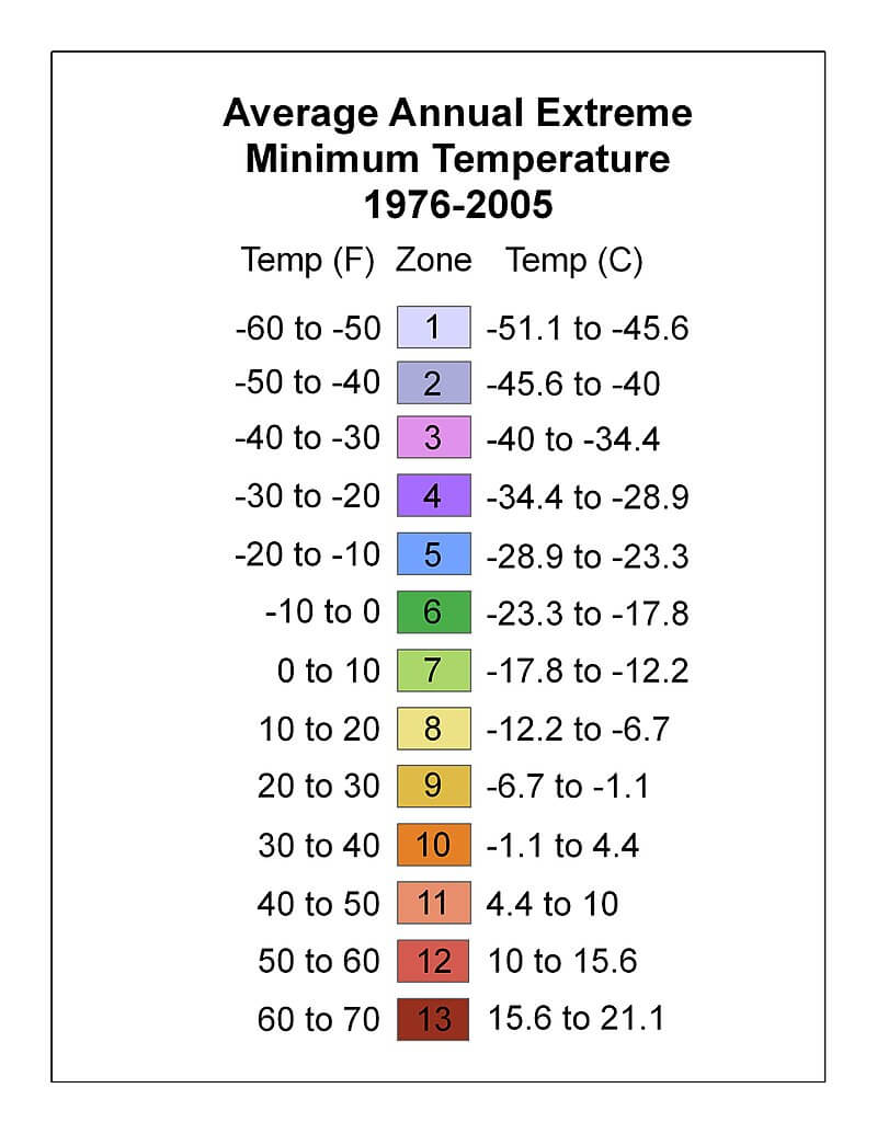
These maps relate to the minimum temperatures that are expected to be seen across the US. The United States is broken out into 13 different growing zones, with minimum expected temperatures that look like this:

The thirteen US growing zones are also broken into two further sub-zones, A and B. Zone A represents the first 5 degrees Fahrenheit (i.e. 10 to 15 degrees), whereas Zone B represents the last 5 degrees Fahrenheit (i.e. 15 to 19 degrees). For example, if minimum low temperatures reached -22, that would be zone 4a. Alaska features regions in zones 1 through 8, the largest temperature spread of any US state.
These maps are really important for growing perennials, as these plants generally also feature minimum temperatures at which they’ll be expected to survive.

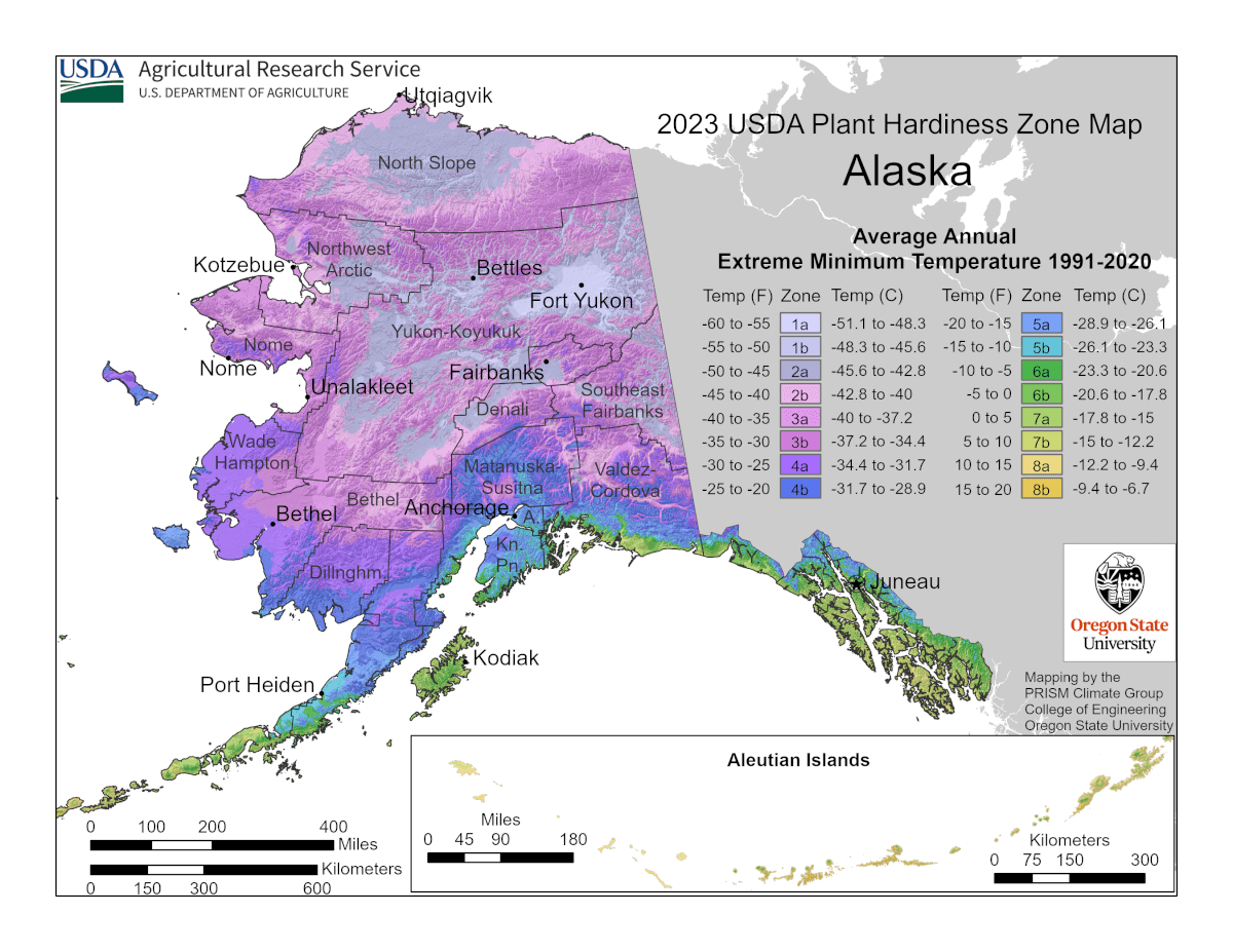
This next-gen map of Alaska is immediately striking. We like that it’s entirely customized to Alaska, reflecting our eight northern growing zones, the entire Aleutians in a separate cutout and physically identifies several important Alaskan agricultural locations.
In somewhat loose ways, they also impact annual growing as well. There are generally correlations between first and lost frost dates and these zones.
In addition, the USDA has introduced newer, better ways to interface with the USDA hardiness maps. Their webpage has introduced a searchable map, overlaid with roads, that help the gardener identify their precise growing zone.
As a side note, we generally advise that some growing zones are a little bit more involved than simple colors on a map. Small microclimates may not be reflected in these maps and therefore experimentation by the grower is advised.
We were quite pleased with the higher resolution images the USDA has made available, as well as the state and region specific maps they are now providing.
As some might expect, through experience or other research, there have been significant trends towards areas warming in Alaska. There are also areas that indicate they are cooler than the previous 2012 edition map showed.
According to the producers of the data (Oregon State University), these trends aren’t as much a reflection of any climatological changes, but rather better resolution of data. The authors specifically point out Alaska as being a general beneficiary of this better data resolution.
In our area (Fairbanks), it’s interesting to see that there are areas now classified in zone 4a, particularly in the surrounding hills. These areas were largely classified as zone 3b previously.
In some places, like Southcentral Alaska, many areas in this region have been upgraded to zone 5a. Overall, the new maps reflect the significant climate nuance we see from both elevation and coastal influence.
As for major changes you might expect with growing, I wouldn’t anticipate these maps will introduce any changes. Seeding schedules will largely stay the same, as will your general approach to cold climate growing.
We will be updating the images and references we use on our site to reflect this new data set over the winter. We’ve had to use 3rd party sources for address-specific zone information, we’re super glad we can now point users to the USDA’s raw data instead!
We think it’s great that the USDA is producing finer resolution information on climate. It’s very helpful information overall and will help us northern growers become better at our craft!

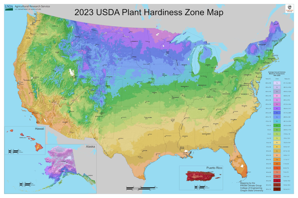
As usual, we’ll leave the lower 48 for last. They got updated zone data as well, also including state level zone data. Hawaii also got its own, dedicated regional map as well that is also interesting to review, especially if you fantasize about growing in tropical zones.

